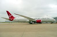
Virgin Atlantic Airways VIR22Q - Virgin Atlantic Airways - 787-9 Dreamliner/Dreamliner (Srs.9)/787-9 BBJ/BBJ (787-9) (B789) - G-VMAP

Additional Data
Disclaimer: The source of the above image is wikimedia and is copyright John Taggart (under cc-by-sa-2.0). This system may not show the actual aircraft with 100% accuracy.

Additional information as it flew nearby

Ground Speed
941 km/h
Heading (degrees)
59 (Northeast)
Altitude
11887 m
Coordinates
Lat: 48.2586 Lng: -58.5401
Date (UTC)
Oct 8, 2024 4:34
Distance from Departure Airport
1834 km
Distance to Arrival Airport
4067 km

Last 5 Flights of this Aircraft (G-VMAP)

IdentAircraftComing fromFromGoing toToOwner nameOwnerDate
G-VMAP - B789 - Virgin Atlantic Airways VIR22Q BOEING 787-9 Dreamliner B789 Washington, United States (KIAD) KIAD
5793 km
London, United Kingdom (EGLL) EGLL
119 km
Virgin Atlantic Airways Virgin Atlantic Airways Tue, 08 Oct 2024 08:49:50 +0000 8/10/2024 8:49 am
G-VMAP - B789 - Virgin Atlantic Airways VIR22Q BOEING 787-9 Dreamliner B789 Washington, United States (KIAD) KIAD
1834 km
London, United Kingdom (EGLL) EGLL
4067 km
Virgin Atlantic Airways Virgin Atlantic Airways Tue, 08 Oct 2024 04:34:33 +0000 8/10/2024 4:34 am
G-VMAP - B789 - Virgin Atlantic Airways VIR22Q BOEING 787-9 Dreamliner B789 Washington, United States (KIAD) KIAD
1125 km
London, United Kingdom (EGLL) EGLL
4777 km
Virgin Atlantic Airways Virgin Atlantic Airways Tue, 08 Oct 2024 03:49:47 +0000 8/10/2024 3:49 am
G-VMAP - B789 - Virgin Atlantic Airways VIR21K BOEING 787-9 Dreamliner B789 London, United Kingdom (EGLL) EGLL
5760 km
Washington, United States (KIAD) KIAD
146 km
Virgin Atlantic Airways Virgin Atlantic Airways Mon, 07 Oct 2024 23:56:44 +0000 7/10/2024 11:56 pm
G-VMAP - B789 - Virgin Atlantic Airways VIR21K BOEING 787-9 Dreamliner B789 London, United Kingdom (EGLL) EGLL
5129 km
Washington, United States (KIAD) KIAD
791 km
Virgin Atlantic Airways Virgin Atlantic Airways Mon, 07 Oct 2024 23:06:28 +0000 7/10/2024 11:06 pm